
Earthquakes can cause catastrophic loss of life and devastate buildings of all sizes. Is it possible to discover evidence for an earthquake that happened in the distant past? Today, modern scientific methods coax the Earth into giving up her secrets. New fields of archeology and geology have revealed convincing evidence of ancient earthquakes and astonishingly, may even have illuminated a couple of well known earthquakes from the Bible.
A number of earthquakes are recorded in the Bible. In most cases, these are not natural events but manifestations of divine power. The inauguration of the Mosaic law covenant at Mount Sinai was accompanied by a fear-inspiring earthquake and possibly even volcanic action (Exodus 19:18). The rebel Levite Korah, along with his co-conspirators were executed by means of what may have been a divinely sent earthquake (illustrated above):
“And the earth opened and swallowed them up, along with their households and everyone who belonged to Korah and all their goods. So they and all who belonged to them went down alive into the Grave, and the earth covered them over, so that they perished from the midst of the congregation.” (Number 16: 32, 33)
Some have speculated that the collapse of the walls of Jericho was caused by an earthquake (if so, the survival of Rahab’s home shows it was a very selective one). On occasions, an earthquake was a divinely ordained means of rescue, as was the case when the Apostle Paul and his companion Silas were released from a prison in Philippi:
“Suddenly a great earthquake occurred, so that the foundations of the jail were shaken. Moreover, all the doors were instantly opened, and everyone’s bonds came loose.” (Acts 16: 26)
Famously, earthquakes marked the death of Christ as well as his resurrection (Matthew 27: 51-54; Matthew 28: 1,2). All of these earthquakes were supernatural events and evidently quite localised.
But natural earthquakes in the Bible lands are not unusual. Minor earthquakes shake Israel and her neighbours several times a year. Statistically, a major earthquake hits Israel every 80 to 100 years. The border between Israel and neighbouring Jordan runs along an active fault line called the Syrian-African fault line. The Jordan river runs down from the Sea of Galilee into the Dead Sea, 400 metres below sea level which is the lowest point on dry land in the world. The Jordan valley was created by the Syrian-African fault line, which used to be more commonly known as the Great Rift Valley. The Great Rift Valley extends down from Lebanon, through Israel and all the way through east-Africa to Mozambique. Along this rift, two of the Earth’s tectonic plates are slowly, imperceptibly drifting apart.
Ancient builders in Israel may have had some awareness of how to build with earthquake resistant (though not earthquake proof) techniques. The Bible describes the building of the walls around the courtyard of the temple built by King Solomon this way,
“Around the great courtyard were three rows of hewn stone and a row of cedar beams, like that for the inner courtyard of the house of Jehovah and the porch of the house.” (1 Kings 7: 12)
This technique of alternating rows of stone with a row of cedar beans seems to have been used to mitigate the damage caused by earthquakes. The cedar beams would have some ability to absorb the pressure on the walls exerted during an earthquake. Evidence of this construction technique has been discovered at a number of sites throughout Israel that date back to Solomon’s time, including at Dan and Megiddo.
History records a number of great earthquakes devastating the region. Even in relatively modern times the area has been repeatedly struck with deadly quakes. In 1927, the Jericho earthquake rocked Jericho and Jerusalem costing an estimated 287 lives and causing widespread destruction of homes and buildings. That quake was estimated at 6.3 on the Richter scale. An earthquake in the Galilee region in 1837 was far deadlier, claiming an estimated 6-7000 lives. That quake is estimated to have had a magnitude of 7.0 on the Richter scale.
This leads to a natural question. Since the Richter scale was only developed in the 1930’s and since modern seismographic detection equipment was only invented at the end of the 19th century, how can we reliably measure the magnitude of an earthquake from centuries ago? A whole branch of archeology called “Archaeoseismology” (or as I prefer, archeoseismology) is dedicated to studying ancient earthquakes through archeological analysis. Αncient structures can be studied for signs of earthquake damage. Buildings destroyed in an earthquake look very different than those destroyed by fire or by deliberate demolition. For example, in an earthquake buildings tend to fall in the same general direction. They fall in the opposite direction of the ground motion caused by the quake. For that reason, after an earthquake one may expect to find groups of columns or buildings to have fallen in a common direction. Homes destroyed by fire, flood or mischief can be expected to be found in a much more anarchic state.
In addition, the archeoseismologist will examine historical accounts of those who lived through the earthquake for telling details such as the extent of damage, how long the tremors continued and how far away the tremors were felt. Based on these details a score is assigned using a scale called the Mercalli scale (out of a possible high score of 12). Sometimes the epicentre for the quake can be estimated by examining historical accounts. If a number of Mercalli values can be assigned to a number of different locations in the vicinity of the epicentre, then the magnitude of the quake may be estimated by comparing the effects to that of modern earthquakes that have known Richter magnitude and Mercalli values.
Visitors to Israel have the opportunity to see a stunning example of earthquake damage from over a thousand years ago. Near the head of the Jordan river valley are the ruins of an ancient city known in the Bible as Beth-Shean (Beit Shean). Most famously, Beth-Shean is the city from which the Philistines hung the bodies of King Saul and his son Jonathan after their deaths in battle at Mount Gilboa (1 Samuel 31:10). By Jesus day, the city had been renamed “Scythopolis” and was the largest of the ten Greek influenced autonomous cities called in the Bible the “Decapolis” (Mark 5:20). During the Byzantine period the city seems to have become primarily Christian but during the 7th century the city and the entire region fell to the Muslim conquest. During all this time the impressive Roman buildings with their characteristic colonnades remained in place (although the city had been extensively rebuilt after an earthquake in 363 C.E).
This all changed on the morning of January 18, 749 C.E. A deadly earthquake known as the Galilee earthquake or the Golan earthquake devastated cities in the Galilee region killing thousands in Jerusalem alone and damaging homes as far away as Egypt. Reportedly there were tsunamis along the Mediterranean coast. After-shocks plagued Damascus for days. Archeoseismologists have determined the earthquake had a magnitude of 7.0.

Beth-Shean, Israel. Columns in the background have been reconstructed. Columns in the foreground remain were they have been since falling in a devastating earthquake in 749 C.E. Characteristic of earthquake damage, fallen building material is oriented in the same general direction.
Extensive archeological work has been done at Beth-Shean since the 1950’s. Research has shown that the old Roman part of the city with its monumental architecture was never rebuilt after the earthquake of 749. Today, visitors to the site looking down from the archeological tell (the artificial mound created by centuries of people living on the same site) can see the partially reconstructed remains of the column lined Roman cardo (main street). However, in places the columns have been left laying just where they fell during the great earthquake. Visitors can see for themselves the pattern characteristic of earthquake destruction, columns laying in generally the same direction.
Another means of studying ancient earthquakes does not require archeological support or contemporary reports. Just as annual snowfall causes layers to form which can be identified in ice cores samples taken from arctic icecaps, similar patterns can be seen in sedimentation cores taken from the bottom of a lake. An annual layer of sedimentation is called a “varve”. When a lake is above a fault line, such as the Dead Sea, a sedimentation core sample taken from under the lake can reveal the seismic history of the area. During high intensity shaking events like an earthquake, the appearance of a varve is deformed in characteristic ways. These varves will appear very different than the way sediment normally builds on a lake bed. Still more ancient varves can sometime be seen in cliff sides that in the distant past were once underwater.
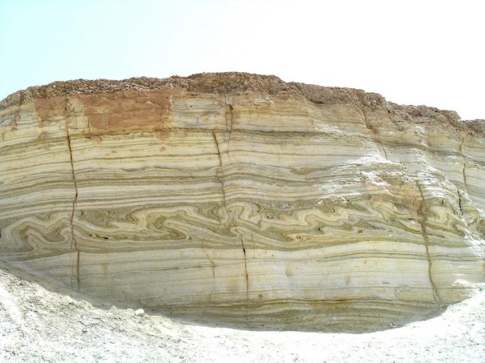
This Dead Sea cliff side was once under the Sea. The layers in this rock are called varves and are created by regular cycles of sedimentation. Earthquakes deform the regular characteristics of a varve. Can you spot the earthquake layer (“Seismite”) in this rock?
Using this technique, geologist Jefferson Williams of Supersonic Geophysical and his colleagues Markus Schwab and Achim Brauer of the German Research Center for Geosciences studied three sedimentation cores taken from a beach on the Dead Sea. In 2011, they reported their findings in the “International Geology Review“. They determined that in addition to a known earthquake in 31 B.C there had been another local earthquake sometime between 26 and 36 C.E. The core samples came from a spot (Ein Gedi) just 23 kilometres (14 miles) from Jerusalem. In view of the suggested date range and the location one can’t help but make the obvious connection that the earthquake they discovered may well be the earthquake that immediately followed the death of Jesus:
“And look! the curtain of the sanctuary was torn in two, from top to bottom, and the earth quaked, and the rocks were split.” (Matthew 27:51)
The dating of the “seismic event” is certainly suggestive, but not conclusive. A Bible critic might counter that this earthquake may be some other unrecorded seismic event that just happened to occur during the same relative short time period. No amount of evidence will ever be satisfactory for some people. Less controversially, the study of varves and sedimentation cores illustrate how the Earth records its own geological history and how a skilled interpreter may study that history.
Another natural earthquake in the Bible made an impact on Bible writers separated by centuries. The prophet Amos, a humble agricultural labourer was inspired to prophecy, “in the days of King Uzziah of Judah … two years before the earthquake.” (Amos 1:1)
Well over 200 years later, the memory of that earthquake remained. The prophet Zechariah speaks of a time when:
“You will have to flee, just as you fled because of the earthquake in the days of King Uzziah of Judah.” (Zechariah 14: 5)
Hazor was at one time the largest fortified city in the northern kingdom of Israel. Archeological research began on the Hazor mound (“tell”) in 1955. Archeologists found that over time the city had been destroyed and rebuilt twenty-two times, each successive city on top of the last. By examining the coins, pottery styles, writing samples and using other scientific techniques it is possible to date each successive layer (“strata”). In the layer dated to the mid-8th century B.C, archeologists found widespread evidence of a catastrophe.
They found tilted walls, inclined pillars, and collapsed houses all generally leaning or

This wall at Hazor is believed to have tilted during the Uzziah Quake of the mid-8th century B.C.
fallen in a southward direction. In one house within that layer, household objects were found buried beneath a collapsed ceiling. These are all classic characteristics of earthquake damage. The general southward orientation of the fallen ruins suggests that the earthquake’s epicentre was in the the north.
In Gezer far to the south of Israel, archeologists have discovered the same thing in the layer associated with the mid-8th century B.C. Heavy walls lie fallen course upon course. This demonstrates that the entire wall collapsed suddenly. Further, heavy stones in the wall are cracked or are displaced from their foundations. As at Hazor, evidence shows that the earthquake came from the north of the city. Archeologists find the same thing in a number of other Israelite cities including Lachish, Tell Judeideh, ‘En Haseva and Deir ‘Alia.
With so much evidence from so many locations, archeoseismoligists can create a reasonable estimate of the earthquakes magnitude. An article published in the year 2000 in the International Geology Review assigned the earthquake a minimum magnitude of 7.8 but stated that it was probably as high as 8.2! To put that in perspective, the earthquake that devastated Port-au-Prince in Haiti in 2010 had a magnitude of 7.0. If the upper estimate of the Uzziah earthquake is correct, researchers believe that it would have been the most powerful earthquake to afflict the region in 4000 years! Not surprisingly, geologist’s have discovered earthquake layers (called “Seismites”) in cliff-sides near the Dead Sea (the Sea level has dropped dramatically since ancient times) that they believe may be associated with the earthquake of Uzziah’s time.
Little wonder than that Zechariah and his readers would remember the terrible event well over 200 years after it had occurred.
Today, earthquakes continue to imperil major cities around the world and cause massive loss of life as seen in recent years in Haiti, Japan, Nepal, Pakistan, China, Indonesia, Mexico and many other places. The great cities of Israel, Jordan, Lebanon and others in earthquake prone zones all around the world continue to prepare for the earthquake that everyone refers to simply as “the Big One”. Bible students can’t help but to be reminded of Jesus prophetic words that the last days would be marked by, “earthquakes in one place after another.” (Matthew 24: 7)
Image Credits:
“Death of Korah, Dathan and Abiram” by Gustave Dore. Created circa 1865. {PD} Source: Wikimedia Commons
Beth-Shean photo by author. Taken in 2013.
Cliffside from a Dead Sea canyon called Nahal Pratzim. Picture taken by Daki. Source: Hebrew Wikimedia Commons
Archeoseismic Damage At Hazor From Uzziah Quake. Image from: Austin, S. A., et al. (2000). “Amos’s Earthquake: An Extraordinary Middle East Seismic Event of 750 B.C.” International Geology Review 42(7): 657-671.
